Boone County

Boone County, in the north-central part of the
State, is bounded north by Randolph and Audrain Counties, east by Audrain and
Callaway, south by Cole and Moniteau, and west by Cooper and Howard Counties,
and contains 430,600 acres.
Population in 1821, 3,692; in 1830, 8,859; in 1840, 13,561; in 1850,
14,979; in 1860, 19,486; in 1870, 20,765, of whom 16,727 were white, and 4,038
colored; 10,420 male and 10,345 female; 20,439 native (14,990 born in Missouri)
and 326 foreign.
History
The first settlement, in what is now Boone County, was made in 1812-13, at what
a few years afterwards was called "Thrall's Prairie," by John Berry and Reuben
Gentry; the latter was the father of Gen. Wm. Gentry, of Pettis Co. In 1815,
immediately following the treaty by which the Indians relinquished all their
country in Missouri Territory, north of the river. Robert Hinkson, William
Callaham, William Graham, Reuben and Henry Cave located along the old "Boone's
Lick" trail, or old St. Charles Road, leading from St. Louis to Old Franklin,
which was made by Benjamin Cooper and others in 1810. In 1816, Augustus Thrall,
Dr. Geo. B. Wilcox, Tyre Harris, Overton Harris, Anderson Woods, Wm. Leintz,
the Wilhites and others settled on what is now Thrall's Prairie, in the western
part of the county. These settlers are remembered as the honest and substantial
pioneers of Boone, and are now represented by a line of worthy descendants,
who have nobly developed the work of civilization and progress, which their
courage and energy inaugurated. The years 1817 and 1818 witnessed a great
influx of population to the "Boone's Lick Country," as all Central Missouri
was then familiarly called. The immigrants were a solid class of people, who
possessed the intelligence to perceive the undeveloped resources and bright
future of Missouri, and the heroism to overcome the difficulties in its
attainment. These early settlers were mainly from Kentucky (principally
Madison County), Virginia, Tennessee and North Carolina. Of late years all
sections of the Union have been represented, and a cordial reception awaits
the honest immigrant. The county was organized from Howard, November 16th,
1820, and named in honor of Daniel Boone. The county seat was located at
Smithton, 1 mile west of the present Columbia court-house, and named in honor
of General T. A. Smith. The first county court was held February 23d, 1821,
with officers as follows:,br />
Anderson Woods, Lazarus Wilcox and Peter Wright, justices;
Warren Woodson, Clerk.
The first circuit court was held at Smithton, beneath the branches of a sugar
maple, on April 2nd, 1821:
David Todd, judge;
Roger N. Todd, clerk;
Overton Harris, sheriff;
Hamilton R. Gamble, circuit-attorney.
The county seat was removed from Smithton to Columbia, November 15th, 1821, on
account of a failure in digging wells to strike veins of water in the former
place.
The first circuit court held in Columbia, was December 7th, 1821. The first
election in the county was on August 5th, 1822, at which 557 votes were polled.
Physical Features
About 76,800 acres of the county is beautiful undulating prairie, and the
remainder 353,800 acres is timber land, which is rolling, except that along the
creeks and the Missouri River, which is hilly. The timber is mainly white oak,
sycamore, cottonwood, black and white ash, hackberry, linn, black and white
walnut, maple, birch, cherry, elm, white and shell-bark hickory, honey locust,
box elder and sassafras. Along the bluffs red cedar grows to perfection. The
most valuable kinds of timber are still abundant.
Boone is well watered. Cedar Creek in the east is a part of the eastern
boundary line between Boone and Callaway, and empties into the Missouri about
3 miles below the south-east corner of the county. Petite Bonne Femme (Little
Good Woman) rises near the center of the county and flows in a south-easterly
direction to the Missouri. The Roche Percee (Pierced Rock), the most important
stream in the county, rises on Grand Prairie in the extreme northern part,
flows southward receiving on the east, Hinkson, Rocky Fork, Silver Fork,
Graves' Fork, and on the west Lick's Fork and Sugar Creek, so called from the
sugar maples on its banks. The Moniteau, or river of the "Great Spirit,"
interlocks its head waters with those of the Roche Percee, forming a portion
of the western boundary, and empties into the Missouri River near Rocheport.
The larger streams, though rapid and containing a great quantity of water when
swollen by heavy rains, are not, ordinarily, reliable as water powers.
There is no richer soil in the State than can be found in Boone County. It is
diverse in character, and is adapted to the growth of all products known to
the latitude.
Professor G. C. Swallow enumerates the various soils of the county as follows:
"The Elm, Resin Weed, Hickory and Equivalent Prairie, the White Oak and the
Magnesian Limestone lands. The Elm lands abound, near Thrall's Prairie, in the
west, and the Hickory lands around Columbia and between that city and Rocheport,
the White Oak lands in the south-east, west and north-west. The rich bottom
lands have been greatly diminished in the last thirty years by the treacherous
encroachments of the Missouri River, and, unless saved by artificial means,
will all finally be swept away."
All the cereals are cultivated with great success. The farming community are
very prosperous as a rule. Many farmers within a few years have amassed
fortunes, relying alone on the marketable products of the soil and raising of
stock.
About 7 miles north-west from Columbia is Conner's Cave, the entrance of which
is 20 feet wide and 8 feet high, which has been penetrated for several miles.
A short distance above Rocheport are high cliffs of rocks, containing Indian
hieroglyphics and numerous caves and springs. There is a natural bridge of
considerable interest at Rockbridge, or McConathy's Mills, 6 miles south from
Columbia, and in the southern part of the county there are numerous Indian
mounds.
On the University grounds at Columbia is a mineral spring possessing superior
medicinal qualities. The analysis of one gallon of the water by Paul
Schweitzer, Professor of Analytical Chemistry in the University, gives the
following result: silicic acid, 1.458 grains; alumina, 0.787; sulphate of
lime, 95.777; sulphate of magnesia, 31.342; sulphate of soda, 16.224
bi-carbonate of lime, 14.527; bi-carbonate of iron, 5.505; carbonic acid
(free), 15.517; organic matter, 0.073; total, 181.210. The free carbonic acid,
as found in the water, amounts to 32.147 cubic inches. This favorable showing
must, in course of time, render this spring a frequent resort for invalids.
Agricultural Productions
The various soils of the county are adapted to the growth of corn, wheat, oats,
rye, barley, beans, potatoes, sorghum, hemp and tobacco; the latter principally
of a coarse quality. Much of the land is adapted to grape-culture, and this
branch of business is largely on the increase. Great numbers of new vineyards
are being planted every year, and soon the wine product will be an important
item.
This is the home of blue grass; it often keeps one-fourth as much stock through
the winter as in summer. During the summer, with the blue grass there is a fine
growth of white clover, which is indigenous to the soil.
The advantages which Boone possesses for the shipment of stock and produce,
with the great Missouri on its south-western boundary, its rail-road
connections, and its 6o miles of splendid turnpike, are not surpassed by those
of any county in the State.
A few Alderneys have been imported, and many short-horned cattle are annually
reared in the county. Many of the leading farmers are turning their attention
in this direction.
Great improvement has been made in hogs, by the importation of Berkshire,
Essex, Suffolk and the mixed breeds, Poland-China and Chester White. Cotswold,
Leicester, Southdown and Merino sheep have been imported, and great improvement
effected thereby. The "Prize Model Farm" of the State is on Thralls Prairie,
and owned by Hon. John W. Harris, a son of one of the first settlers.
Good farming and stock-raising lands, accessible to market and well-improved,
sell at from $20 to $30 per acre. The best quality of land sells at from $40
to $50 per acre.
Mineral Resources
But little has been done toward the discovery and development of the mineral
resources of the county. Coal is the most important mineral product, and its
development is increasing. More than one-half the northern part of the county
is underlaid with superior coal, which generally lies near the surface. There
are five beds, varying in thickness from one to five feet, and producing block
coal, valuable for smelting iron, also a gas coal, nearly equal to that of
Pittsburg. Of other minerals, hydraulic limestone, fire clay, potters' and
brick clay, limestone and sandstone suitable for building purposes, sand and
limes for cements and gravel for roads and streets, all abound in large and
superior quantities. Iron ores of fine quality are also found in several
places. Lead has been found, but its extent is unknown. Sulphur also exists
in considerable quantities.
The Manufacturing Interests, aside from the country flouring and
saw-mills, consist of tobacco, wagon and woolen factories, and are noticed
under the different towns.
Wealth
Valuation of the county per census of 1870, $15,000,000.*
Railroads
The St. Louis, Kansas City & Northern Rail Way traverses one-half of the
northern border of the county, having 12 miles of track. A branch of this
road, 22 miles in length, connects Columbia with the main road at Centralia.
To aid in the construction of these roads, the citizens of the county
subscribed $325,000. They also subscribed $50,000 to aid the Louisiana & Mo.
River Rail Road, which has been surveyed and graded through the county from
east to west.
Boone County has 4 excellent turnpike roads radiating from her county seat,
one to Rocheport, west, distance 13 miles; one to Rocky Fork Church, in the
north-western portion of the county, distance 7 miles; one east to the
Callaway border, distance 10 miles, and one to Claysville on the Missouri
River, via Ashland, in the south-eastern part of the county, distance 28
miles. The principal streams are bridged, and the roads are kept in splendid
condition, and through them the farmer has, at every season of the year, a
ready and easy market communication.
The Exports are corn, wheat, rye, oats, tobacco, fruit and stock.
Educational Interests
The public schools of this county are in a flourishing condition. There are in
the county 115 sub-districts, 113 school-houses, valued at $60,910, furniture
worth $4,260; 8,981 children of school age, 5,671 attending school, and 136
teachers. The annual cost of the public schools is about $38,000. There are
also a number of excellent private schools and colleges noticed under the
different towns, and the University of Missouri and Agricultural College
described under heading of Columbia.
Boone County Places in 1875
Ashland, 14 miles east south east of Columbia, in the center of a rich
farming country, has a wagon manufactory, 1 church, Baptist, 1 public school,
several stores, and a brisk trade. Population 300.
Brown's, on the Col. Branch of the St. L., K. C. & N. Rail Road, 8 miles north
of Columbia.
Burlington, near the Missouri River, 18 miles south of Columbia and 14
and miles north west of Cedar City, has a few stores.
Bush's, on the Columbia Branch of the St. L., K. C. & N. Rail Road, 6
miles north of Centralia.
Centralia, on the St. L., K. C. & N. Rail Road, 122 miles from St. Louis,
at the junction of the Columbia Branch, beautifully situated on the dividing
ridge between the Missouri and Mississippi Rivers, was laid out in May, 1857,
incorporated in 1867, and is surrounded by a beautiful, fertile and well
cultivated prairie. It contains an excellent public school and several private
ones, 1 newspaper, The Guard, published by Adam Rodemyre, 2
churches-Christian and M. E. Ch. South, 3 hotels, 1 wagon-shop, 1 hay-press,
1 lumber-yard, 1 flouring-mill, and about a dozen stores. The famous "Bill
Anderson Massacre," of September 28th, 1864, occurred at Centralia.
Population about 700.
Claysville, near the Missouri River, 6 miles north west of Cedar City,
and 28 miles south east of Columbia, contains a few stores.
COLUMBIA, the county seat and principal city, on the Columbia Branch of the
St. Louis, Kansas City & Northern Rail Way, 22 miles south of Centralia (junction), is
located in a rich and healthy region of timber, near the center of the county.
It is one of the most delightful places in the State, its streets being
regularly laid out, many of them nicely paved and shaded with beautiful trees.
The business houses are generally substantial brick buildings, some of them
elegant and imposing. Its outskirts are bordered with fine lawns, in which
stand elegant residences.
The enterprise, culture and intelligence of the people of Columbia have won
for it the honored and classic title of "The Athens of Missouri." It is the
acknowledged seat of learning of the State, and bases its prospects and its
hopes chiefly on its educational interests. For such reason it will
necessarily continue to be the abode of much refinement and wealth.
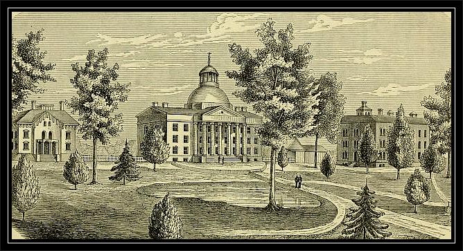
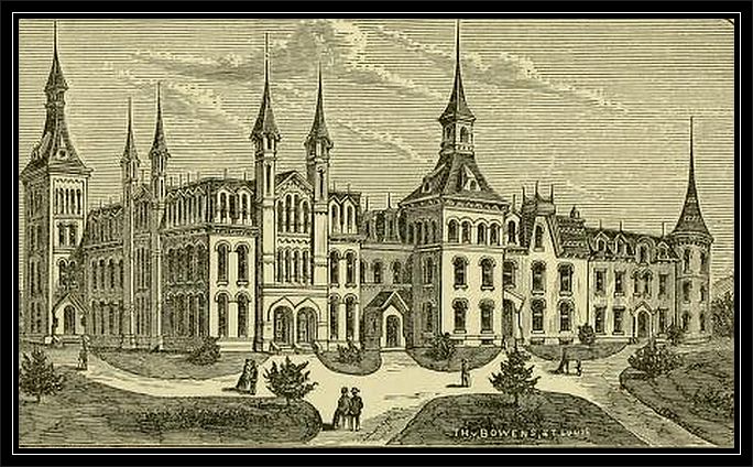
State University at Columbia, Missouri
The State University, located at this place, is the most prominent educational
institution in Missouri. It was established by an act of the Legislature in
1839, upon an endowment made in 1820 by Congress, in the form of two townships
of land, known as the "Seminary Lands." This endowment had grown by
accumulation to the value of $100,000, when the institution was founded. The
present endowment is about $223,000. The citizens of Boone County contributed
the generous sum of $117,500 as a bonus for the location of the University at
Columbia. The first president was J. H. Lathrop, LL. D., elected in 1840. The
present incumbent, Daniel Read, LL. D., was elected in 1866. The supervision
of the University is vested in a Board of Curators, who are appointed by the
Governor and confirmed by the Senate; and upon this Board devolves the duty of
selecting the president, professors and tutors. The University contains a
library of 7,000 volumes, a cabinet with 120,000 specimens, and an edifice
erected by private subscription at a cost of $85,000. The University embraces
at present in its group of schools, besides the regular academic course, a
preparatory school, an agricultural college, a college of normal instruction,
a school of mines and a law and medical school. All these schools are located
at Columbia, except the school of mines, which is at Rolla, Phelps County. The
advantages of the University are extended to women on equal terms with men.
All resident youth in the State, upon the payment of an entrance fee of ten
dollars, are entitled to the benefits of the University, except in the
strictly professional schools.
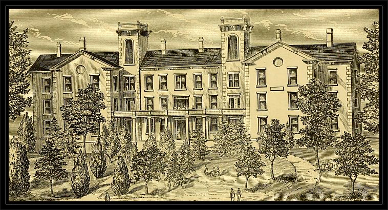
Christian College For Young Ladies at Columbia, Missouri
Christian College, for young ladies, under the patronage of the Christian
denomination, is a flourishing institution, justly celebrated for its able
management as well as for the culture and proficiency of its pupils. Annual
attendance about 200. President, Elder J. K. Rogers.
Stephens Female College at Columbia, Missouri
Stephens College, for young ladies, under the patronage of the Baptist
denomination, was located here in 1870, and named in honor of Hon. James
L. Stephens, who gave it a munificent endowment. It is not surpassed in the
State as a seminary for young ladies. It has a liberal patronage from Missouri
and other States. President, Rev. E. S. Dulin, D. D., LL. D. There are also
numerous other schools, well conducted and in a prosperous condition.
There are 7 churches--Baptist, Christian, Presbyterian, M. E. Ch., Episcopal,
and colored Baptist and colored Methodist.
There are two newspapers. The Statesman, published by Wm. F. Switzler,
was established in 1843, and, except the Missouri Republican, is the
oldest newspaper in the State; and The Herald, published by E. W.
Stephens, is one of the leading papers in central Missouri; also two monthly
papers, the University Missourian, published by the students of the
State University, and the Chaplet, published by the students of
Stephens College. The Masonic fraternity is represented by large lodges of the
various branches of their order, and the Odd Fellows have a lodge of about 100
members which is increasing rapidly.
The ground on which Columbia now stands, was purchased at the Government Land
sale, November 14th, 1818, by the Smithton company, who, in 1819 laid out
Smithton, one mile west of the present Columbia court house, but failing to
find water in that locality, the town was transferred to the present site of
Columbia in 1821, and it was incorporated the next year. The population of
Columbia was in 1823, 130; 1835, 700; 1840, 770; 1848, 1,008; 1850, 1,022;
1852, 1,139; 1860, 1,541; 1868, 2,501; 1870, 2,954; 1874 (estimated), 3,500.
The city contains 2 banks, 2 hotels, 1 flouring-mill, 1 saw-mill, 1
woolen-mill, 2 wagon and plow manufactories, 1 pork-packing house, 1 carriage
manufactory, 3 lumber yards, 1 flower store and green-house, 1 brewery, and
about 40 stores, with the usual number of shops and smaller industries.
Dripping Springs, a post office 9 miles north west of Columbia.
Eureka, on the Missouri River, 20 miles south of Columbia, contains a
few stores.
Hallsville, (Hickman) on the Col. Branch of the St. L., K. C. &
N. Rail Way, 9 miles south of Centralia, is a good business point. Pop. about 6o.
Harrisburgh, 16 miles north west of Columbia, and surrounded by a fine
farming country, is on the line of the proposed L. & Mo. River Rail Road.
Population about 100.
Hickman.-See Hallsville.
Midway, a post office 7 miles west of Columbia.
Persinger, on the Col. Branch of the St. L., K. C. & N. Rail Way, is 17
miles south of Centralia.
Providence, on the Missouri River, 10 miles south of Columbia; has
several good stores, and a shipping business of considerable consequence.
Rocheport, on the Missouri River, 14 miles west of Columbia, surrounded
by a fine country, is substantially built upon an old "New Madrid claim;" it
was laid out in 1825, and for a time promised to be the city of the interior.
It contains 1 three-story brick high-school building, which is usually
conducted with ability and well attended, 3 churches-Baptist, Christian and
Methodist. The society in Rocheport is far above the average of that of towns
of similar size. The splendid agricultural country adjoining, and the ferry
across the Missouri, make it a thriving business place, and one of the best
shipping points on the Missouri River. It contains 1 large tobacco factory, 1
large steam flouring-mill, 3 wagon and plow factories, 1 tannery, 1
carding-machine, 1 pottery, 1 bank, 12 stores, etc. Population, about 1,000.
Stephens, on the Col. Branch of the St. L., K. C. & N. Rail Way, 16
miles south west of Centralia.
Sturgeon, on the St. L., K. C. & N. Rail Way, 7 miles west of Centralia,
the center of a rich and thickly settled country, has a population of about
700 enterprising people, who have established good public schools and the
Sturgeon Academy. This place was named in honor of Hon. Isaac H. Sturgeon. It
has 1 newspaper-The Leader, published by Thos. S. Carter, and 3
churches-Christian, Catholic and Methodist, 2 hotels, 1 flouring-mill, 1
lumber-yard, and about 12 stores.
Youngers, a post office 8 miles south east of Hallsville.
*Assessed valuation in 1873, $7,164,284. Taxation, $1.35 per $100. Bonded
debt, $383,600. Rocky Fork and Percie Township have $50,000 bonded debt for the
L. & M. R. Rail Road. Between 1866 and 1874 the county paid $45,000 on bonds
and interest, which promptness places it in excellent credit.
Source: Campbell's Gazetteer of Missouri, Revised Edition, by R. A. Campbell,
Published by R. A. Campbell,
St. Louis, Missouri, 1875
|

